Introduction
A glance at a map of Australia shows clearly that the majority of inhabitants live around and on the coasts. But there is significant history attached to those inland ‘corners’ where states intersect. The magazine Placenames Australia had a recent article by Diana Beal titled ‘The Five Corners of Inland Australia’ that seeks to highlight ‘the intrepid work, dedication and contribution of the surveyors’ who mapped these areas in the eighteenth and nineteenth centuries.
Tinteán highlights below (with permission) an extract from the magazine: the story Irish surveyor Francis Peter MacCabe whose work is behind the last mentioned of the five corners. We refer readers to the full article in the March 2023 edition of Placenames Australia.
by Diana Beal
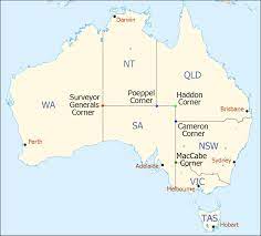
It would be easy to assume that the final corner, MacCabe Corner, where the Murray River (the boundary between NSW and Victoria) crosses the SA border, would be the easiest of all five corners to locate. Possibly, but it is not an unqualified assumption.
The Geographical Names Board of NSW identifies the Corner as being exactly where the NSW-Victorian border (the southern high bank of the Murray River) meets an extension of the NSW-SA border. However, the SA-Victorian border at that point is officially the midline of the Murray. The difference between the two points is about 100m of the Murray River waters.
Nevertheless, MacCabe Corner was named after Francis Peter MacCabe (1817-1897). MacCabe was born in Dublin, the son of Dr James MacCabe and Margaret née Russell. He trained as a surveyor in Ireland and, at the age of 24 years, emigrated unassisted to NSW on the Florentia, arriving in Sydney on 26 October 1841.
MacCabe immediately gained employment with the Department of the Surveyor General as an assistant surveyor.
Files at NSW State Records indicate that MacCabe worked in the Braidwood and Cooma area in the southeast, west along the Lachlan, Murrumbidgee and Murray Rivers, and north in the Port Curtis and Gladstone areas during the next 14 years until the end of 1855, when he resigned from government service.
MacCabe met Jane Osborne in Wollongong and they married on 28 November 1855 and settled there where he managed a coal mine. They had 13 children there until 1872, then moved to Berrima where they had another son. Francis.
MacCabe died in Bowral after a long illness in 1897. MacCabe worked for the Department of the Surveyor General for a relatively short period. However, he obviously was a good bushman, and an active and effective surveyor. He was interested in the history of the land he measured, and he respected and made use of Aboriginal knowledge.
Diana Beal
Initially trained as an economist, Diana discovered family and landscape history when attending a conference in 1988. She then completed a Grad Dip in Local and Applied History (UNE), got the research bug and so completed a research masters, M Phil, at USQ in landscape history. As she was at that time working in a Business Faculty, she decided to go on to complete a PhD in economics (at UQ) to satisfy her bosses. After retirement, she has spent many years researching, writing and publishing, especially for and through the Toowoomba and Darling Downs Family History Society on
topics of local interest – e.g. Squatters of the Eastern Darling Downs (1840-1900s), Black Gully (1840s-1914): The Manufacturing Centre of Toowoomba, A Detailed History of Gowrie Junction. (Gowrie Junction was the most northerly railway station of the inland Brisbane-Sydney rail line up until 1915.)
N.B. for the traveller: In 2008, Monument Australia agreed to erect a monument to Francis MacCabe.

A note on the website (https://monumentaustralia.org.au) says that ‘MacCabe Corner is located an easy half hour drive from the rural hub of Renmark. When standing at the marker you’ll be on Victorian soil, looking across the Murray River at South Australia on the left hand side and New South Wales on the right.’
Initially trained as an economist, Diana discovered family and landscape history when attending a
conference in 1988. She then completed a Grad Dip in Local and Applied History (UNE), got the
research bug and so completed a research masters, M Phil, at USQ in landscape history. As she was
at that time working in a Business Faculty, she decided to go on to complete a PhD in economics (at
UQ) to satisfy her bosses. After retirement, she has spent many years researching, writing and
publishing, especially for and through the Toowoomba and Darling Downs Family History Society on
topics of local interest – e.g. Squatters of the Eastern Darling Downs (1840-1900s), Black Gully
(1840s-1914): The Manufacturing Centre of Toowoomba, A Detailed History of Gowrie Junction.
(Gowrie Junction was the most northerly railway station of the inland Brisbane-Sydney rail line up
until 1915.)
